An Indie Map for Kachemak Bay State Park
Looking for a good map of Kachemak Bay State Park? Until recently, your options were a half-century old USGS map, or a more recent National Geographic map built on this old data and riddled with new errors. We are making something better - a map that uses amazing new datasets, and that is built from the ground up with input from the community of park users.
Field prints on waterproof paper are now available on our store page.
Current Status
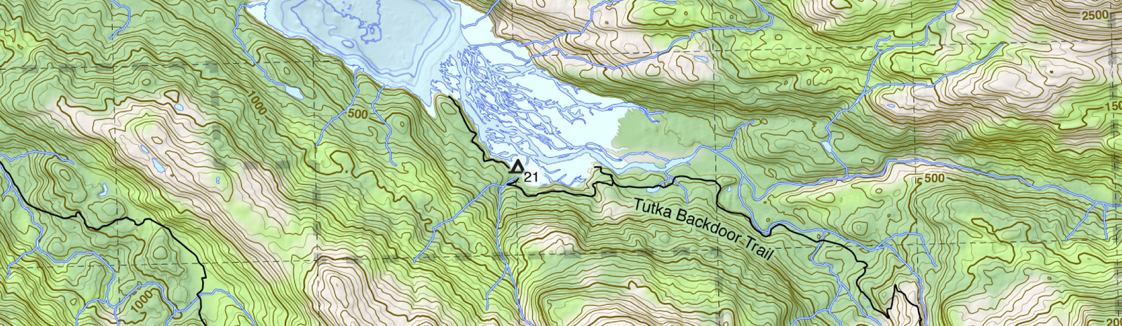
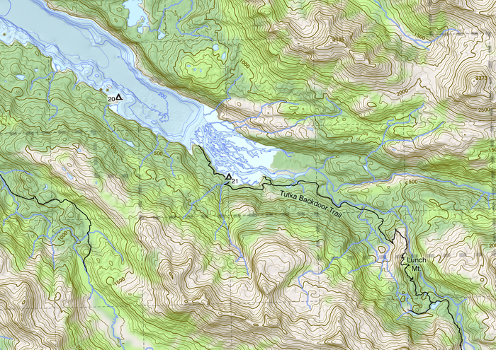
We have produced a draft of the map that includes all of the trails on the Kachemak Bay side of the park. It also includes almost the whole length of the newTutka Backdoor trail, except the very far end at Taylor Bay. It uses new bathymetric mapping in Kachemak Bay, new USGS topography, and hand-mapped intertidal areas, lakes, and other features.
Send an email to contact@groundtruthtrekking.org if you’re interested to either have a large wall map, or field maps printed on waterproof paper. In the coming months we will experimenting different formats - ultimately making them available online and through shops in Homer and elsewhere. Proceeds will support the map itself, the Tutka Backdoor Trail, and studies of tsunami hazards in Grewingk Lake.
Goals of the project
An easily readable source of basic information for the casual user. The general geography of the park should be immediately apparent, and the information should be presented in such a way as to not overwhelm the user.
An effective hiking map , including information that will be valuable for people going off-trail. This includes accurate shorelines, topography, and vegetation. The ideal is that the information provided will be detailed and reliable enough that it will enable people who typically stay on trails to explore off them a bit more.
An outreach tool for adventure tourism and local nonprofits , showing an intricate and beautiful landscape that potential visitors will be excited to explore or help protect.
A window to information not readily apparent to most hikers : Show glacial retreat, lake bathymetry, ecosystem variability, anadromous streams, and geologic features that could easily be missed by most hikers. Help them open their eyes to what can be learned from being in the wilderness.
A novel and beautiful piece of art : Maps are an ancient form of art and data visualization - can we do something novel that doesn’t damage the function of the map? What are the consequences of violating the north-is-up standard? Can we combine digital vector graphics and hand penned art in a way that is distinct and effective? How can we merge the established styles of topo maps and marine charts to provide something the illuminates both the marine and terrestrial world? How do we balance ambition to include a wealth of detail with clarity, and a sense of invitation?
An outreach vehicle for results from studies in the park. When possible, work with scientists to add depth to the map (e.g. literally adding the depth of Grewingk Lake from surveys we did this summer.) Potentially could use it for communicating traditional names and archaeological information…
Data sources
| Data source | Year | Notes |
|---|---|---|
| USGS topography | 2015 | 5 m grid IfSAR elevation data. Though this seems to be an improvement over historic topography, there are major errors that I have been hand-correcting in contours. |
| Hydropalooza bathymetric mapping of Kachemak Bay (e.g. from [) | 2009 | Excellent coverage of most of the bay, except spotty in Halibut Cove Lagoon and in shallow water. |
| Kenai Peninsula Borough orthoimagery | 2012 | Excellent imagery at low tide within the park, but limited in coverage. Provided source for most low-tide, lake, and structure mapping. |
| Alaska High Altitude Photography (from Earth Explorer) | 1985 | Ortho-rectified using Agisoft Photoscan. |
| ShoreZone coastal mapping | 2001 | Provided some initial data, but mostly re-mapped. |
| Open Street Map roads | 2007 | (C) Openstreetmap Contributors. Supplemented a little with local knowledge |
| Kenai National Wildlife Refuge ground cover | 2002 | Often inaccurate - hopefully to be replaced by a new ground cover map coming out in summer 2019 |
| Kenai Peninsula Borough parcel mapping | 2018 | Some parcels were mis-mapped, and had to be hand corrected. |