- Earthquake Hazard in the Region
- What is an active fault?
- Ground Truth Trekking’s Critique and Independent Research
- Summary
A major earthquake could cause the collapse or failure of giant earthworks at the proposed Pebble Mine, so accurate seismic hazard analysis is crucial to the safety of such a mine. Design decisions made early in mine construction are important for seismic safety, making it critical to accurately assess seismic risk before construction begins. Failures resulting from an earthquake could be devastating for the mining operation, the local population, and the environment. A major earthquake could lead to loss of life, interruptions in mine operation, release of contaminated water or fuels, and destruction of expensive facilities. Depending on how the mine is insured, the mining company itself may or may not be severely impacted.
The developer (Pebble Limited Patnership, PLP) and opponents of the mine disagree dramatically about the level of seismic risk. Some opponents of mine development state that the risk is high, noting the history of large earthquakes in Alaska. PLP claims the risk is very low. Meanwhile, state and federal geologists identify the risk in the area as being unknown, observing that there is no published evidence of strong shaking in the area, but also little research overall.
PLP states on its website that, although it believes hazard to be low, it will build the mine as if a nearby fault is “active.” The level of assumed activity and fault proximity is not specified, making this an ambiguous statement. Seismic hazard of active faults can vary widely.
This article is a departure from most Ground Truth Trekking articles, because we have been extensively involved inseismic hazard research at Pebble and have conducted the only non-PLP seismic hazard research in the mine area. Throughout this piece we are relying heavily on our own geologic expertise.
PEBBLE PROSPECT
 — 
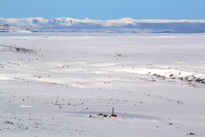
<a class="figure-caption__link" href="/photos/pebble-prospect/">Get Photo</a></figcaption></figure>Research in the Pebble AreaDespite the controversy over the proposed Pebble Mine, very little geological research is being completed in the area. Government scientists have done almost no work in the region, with PLP and Ground Truth Trekking conducting the bulk of the research. It is possible (but not guaranteed) that later in the permitting process government geologists would be tasked with carrying out fieldwork. In a personal communication to Ground Truth Trekking, a PLP geologist recently stated that the developer hopes to collect field data to support an independent analysis, preferably by the Department of Natural Resources (DNR).
PLP’s research
PLP has the best geophysical data on the area, including drill cores, aeromagnetic scans (a way of mapping geologic formations beneath the surface), and LiDAR (a high-resolution surface mapping method), but the company has neither released this data nor used it in its seismic hazard analysis. The lead author of PLP’s seismic hazard report is by self-admission not a geologist (Keystone testimony, 2012) and the seismic hazard analysis does not conform to established geological knowledge. PLP’s work has not undergone scientific peer review, other than in the course of the oral testimony at the 2012 Keystone meeting, where numerous issues were brought up but left unaddressed. PLP’s analysis concludes that earthquake hazard is very low.
Ground Truth Trekking’s research
Ground Truth Trekking has focused both on field research and on analysis and critique of PLP’s work. We have surveyed key sites around Lake Iliamna near Pebble, and we are currently preparing to submit our field results, which present evidence of past earthquakes in the area, for peer review. In analyzing PLP’s work, we released a letter to DNR in 2008 and a detailed critique of PLP’s hazard assessment in 2012.
Why might earthquakes be a problem for Pebble Mine?
The most serious earthquake-related dangers at Pebble Mine would be a major collapse in the pit or underground mine and a dam breach at the giant tailings containment facilities. Either event could precipitate human, economic, and environmental catastrophe, with the pit collapse being the greater human hazard, the tailings breach being the greater long-term economic and environmental risk. Lesser events could include breakage of pipelines, landslides in the mines and rock piles, cave-ins, long-term damage to the water retention capacity of the tailings dams, escape of tailings and contaminated water over dams, and damage to key facilities such as the power plant, pipelines, and rock mill. Any of these events could cause loss of human life, and have serious economic costs and environmental impacts.
After the mine is eventually decommissioned, some facilities, like pipelines, would no longer pose a threat. In contrast, the vulnerability of the tailings facilities would continue indefinitely. In theory, tailings facilities must be maintained forever. At no point will the tailings behind them be expected to become safe. Due to the perpetual danger of the tailings, potential containment failure would pose as much of a threat in the distant future as it would at present, and long-interval earthquakes must be considered.
Natural and Man-Made earthquakes
Pebble is potentially threatened by two different kinds of earthquakes: natural, and man-made.
Natural earthquakes result from large-scale, natural stresses in the earth’s crust. In most cases, natural earthquakes recur sporadically on any given fault, releasing energy accumulated over hundreds or thousands of years, since the last major earthquake. Predicting earthquakes is very difficult, and is done by estimating how often past earthquakes have occured on the fault. It is assumed that future earthquakes will happen with a similar frequency.
In contrast, “man-made” earthquakes are those created or set off by human activities - typically by moving weight on the landscape, or changing groundwater pressure. PLP has documented a system of faults in the area, and these faults might be vulnerable to such effects. Recent dramatic examples of man-made earthquakes include tremors triggered by fracking; quakes related to geothermal development in Switzerland; and a major earthquake linked to the filling a dam reservoir in China.
Pebble Mine would meet some of the key criteria for causing man-made earthquakes. Development would move huge amounts of weight on the land and increase groundwater pressures in some locations. The mine would sit over or near identified faults. As yet there has been no technical assessment published on man-made earthquake risk at Pebble.
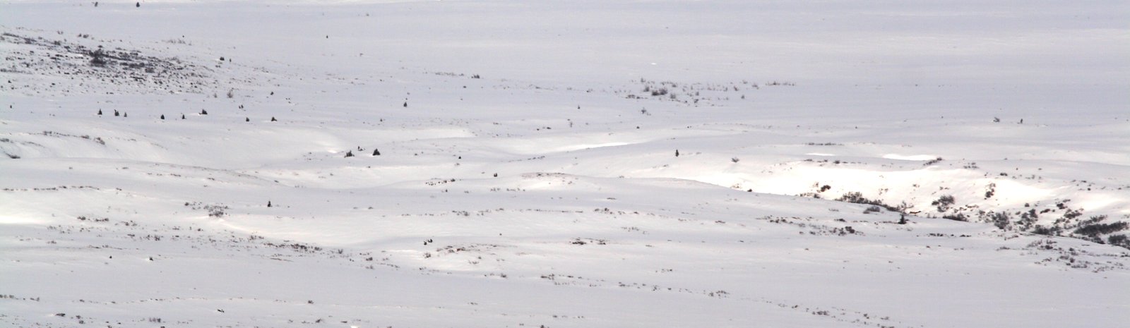
Earthquake Hazard in the Region
Very little is known about Alaska’s actual distribution of active faults, and almost nothing is known about earthquakes in the Lake Iliamna region, near Pebble.
What is an active fault?
The USGS defines faults as “active” if they have confirmed earthquakes on it in the last 10,000 years. There is no official “inactive” fault classification, partly because it is difficult to determine whether a quiescent fault has earthquake potential or not. The vast majority faults routinely identified are not considered active, since there is no immediate reason to consider them so. It is common for non-active faults to generate earthquakes, at which time they are reclassified as “active.”
Why are Faults Important?
Faults are deep fractures in the Earth’s crust. The motion of the tectonic plates composing the Earth’s crust results in the buildup of stress. Eventually stress reaches the point where it causes faults to shift, producing earthquakes. For this reason, earthquake geologists look for faults, and when they find faults, they look for evidence of past motion on those faults. Examples include scars in the Earth’s surface, areas of uplift or subsidence, and evidence of shaking, like liquefaction and landslides.
Especially active faults produce earthquakes every few hundred years and usually leave relatively obvious evidence. Others produce earthquakes very infrequently and may leave no obvious surface expression at all. For instance, the M6.3 earthquake in 2011 that devastated Christchurch, New Zealand, and the M6.7 Northridge earthquake in 1994 caught geologists by surprise and didn’t break the surface of the earth. In both cases, the earthquakes occurred directly under well-studied, populated areas. Even on identified faults that have broken the surface, evidence of past earthquakes can easily be missed, leading to misinterpretation of the fault as inactive. For instance, a M7.1 earthquake occurred in 1999 on the Lavic Lake Fault in southern California - a fault that had been interpreted as inactive.
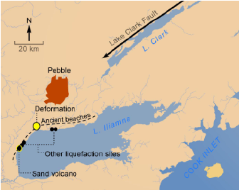
Pebble’s Primary Fault: the Lake Clark Fault
The most significant mapped fault in the Pebble area is the Lake Clark Fault. The Lake Clark Fault extends from the Susitna Valley through Lake Clark Pass, down the Tlikakila River to Lake Clark, and is last mapped about 15 miles short of the mine prospect. The reasonable geological conclusion is that the fault extends further beyond its mapped end, and passes within a few miles of the proposed mine. It could even pass directly through the deposit area, and mineralization along the Lake Clark Fault itself may be the origin of the Pebble ore deposit. The Lake Clark Fault is little studied, and it is not known whether the fault is active and generating earthquakes.
Ground Truth Trekking’s Critique and Independent Research
Ground Truth Trekking’s geological efforts are led by Dr. Bretwood Higman and include field expeditions, review of existing geological literature, and analysis of imagery and satellite data. As mentioned above, we have produced several critiques of PLP’s seismic hazard science, as well as a preliminary report on evidence of past earthquakes, and we are currently preparing a paper on these results to submit for peer review.
Critique of PLP’s seismic hazard analysis
PLP’s most recent public seismic hazard assessment is presented in Chapter 6 of the company’s Environmental Baseline Document (EBD). This assessment consists only of a review of the very sparse existing literature on the Lake Clark Fault and contains no original, relevant geological work. It draws an optimistic conclusion, claiming that there is little risk of earthquakes because the Lake Clark Fault is inactive and likely does not pass near the mine site. However, the support that it provides for this claim amounts to misrepresentation of the scientific literature, and its geologic reasoning does not hold up to scrutiny.
Ground Truth Trekking asserts that decision-makers should not consider PLP’s seismic hazard analysis acceptable. Further scientific research could in fact reveal that there is little seismic risk in area, but the current seismic hazard analysis does not scientifically establish that. The presence or absence of earthquake hazard is an objective, geological question that scientists can answer. Any permitting process should require a seismic hazard analysis that passes a geological peer review (i.e., through the USGS and the Alaska DNR) and conforms to established geological knowledge. Since a mine developer would need to engineer perpetual structures at the site, a responsible company would research actual hazard at the site and then draw conclusions that are conservative, considering the possibility that the risk might prove higher than what is known. This is the opposite of the approach PLP has taken.
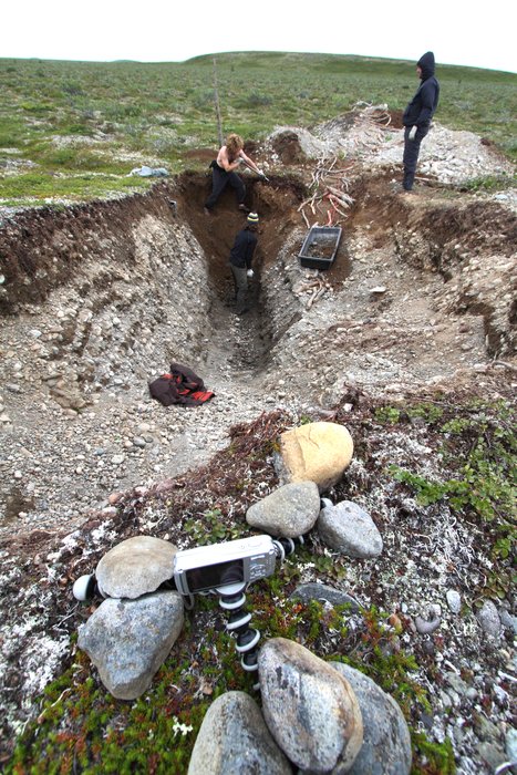
Ground Truth Trekking’s seismic hazard research
Two lines of field evidence suggest that there have been strong earthquakes in the Lake Iliamna area, possibly on the Lake Clark Fault, in recent geological history. Deformation of the landscape, combined with liquefication of the ground that likely resulted from earthquake shaking, suggests that there is an active local fault that produced at least one earthquake within the last 4,000 years.
Landscape deformation
Ground Truth Trekking discovered strong evidence of tectonic motion, while surveying traces of an ancient beach that was stranded high above the current shoreline of Lake Iliamna. As the level of the lake has dropped over the course of the last 10,000 years, since the end of the last Ice Age, it has left a series of ancient beaches, now on dry land. Like all beaches, these ones were horizontal at formation. Examining the highest stranded shoreline, we detected a vertical offset or “kink” in the shore, where its horizontal line suddenly jumped in elevation and then continued horizontally, but at a different level. This deformation likely resulted from motion along a buried fault, though it is possible that the motion was gradual and did not produce earthquakes. The observed deformation is not consistent with post-glacial rebound, the other common source of landscape deformation in the area.
Liquification of Ancient Beach Sediments
When strong shaking affects water-saturated layers of sand and silt, they can “liquefy,” or turn into a fluid slurry that deforms and flows. Evidence of liquefaction is preserved as distortion of the original layered sediments underground. We have identified multiple sites near Pebble showing liquefaction.
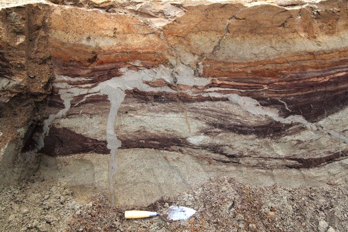
One liquefaction site that we documented at Lake Iliamna consisted of a “sand volcano,” a particularly dramatic liquefaction feature. Buried sands liquefied beneath an ancient marsh, shot upwards through a vertical crack in the ground, and flowed across the ancient ground surface. The event was sudden - probably occurring over the course of minutes or hours - and brought sand to the surface from depths greater than six feet. This feature was then buried by sand dunes, which gradually formed on top of it.
This site provides particularly convincing evidence of earthquake activity, since a number of potential non-earthquake causes for liquefaction - glaciers, landslides, springs, and storm waves - can be eliminated here. The peat this “sand volcano” cuts through dates back 4,000 years, showing that the liquefaction occurred long after glaciers retreated. The site is no evidence that landslides or artesian springs, which are common sources of liquefaction, influenced the sand volcano. The liquefaction furthermore occurred under a marsh, far away from storm waves hitting the beach, which can also cause local liquefaction events, typically in the beach or immediate backshore. Given that we have not identified such clear and dramatic evidence at more sites in the area, our conclusion that this is an earthquake-induced event is tentative. However, in combination with landscape deformation, the presence of the sand volcano suggests that a local fault has generated earthquakes here, in the geologically recent past.
Summary
If Pebble Mine were built, the fate of local communities, the mine, and the environment will all be linked to the seismic stability of the site. An earthquakes that overwhelm the mine’s structures and pollution control systems could cause great loss of life and ecological harm, regardless of whether it is large earthquake on a regionally important fault, or a small man-made earthquake, situated directly under key mine facilities. In either case, the impact could be felt for generations.
While the mine developer’s liability effectively extends through the operating life of the mine itself (or company bankruptcy), the perpetual wastes of the mine will remain on the landscape forever, and pose an ongoing threat. Therefore, the choices that are made now, with respect to project viability and specifications, leave a permanent regional legacy.
The values at stake are extremely high. It is the expert opinion of Ground Truth Trekking that PLP’s existing seismic hazard analysis and rationale are not adequate. Proper scientific research, reviewed by a diverse group of geological experts, is necessary to characterize the actual earthquake hazard in the area. No project should go forward without a rigorous seismic hazard analysis.
Created: Jan. 19, 2018